
Correcting the world map to support cultural development and geographical knowledge

Correcting the world map to support cultural development and geographical knowledge
Maps go beyond being tools for displaying locations and distances, as they contribute to shaping geographical knowledge and the image that individuals have of the world around them. From this standpoint, the discussion about the accuracy of representing continents on maps opens a broader space for thinking about the role of geographical knowledge in enhancing cultural awareness and supporting cultural development paths.
In this context, the United Nations General Assembly’s resolution regarding the representation of the world on maps comes to re-raise questions about the way in which geography is presented, and the extent of its influence on education, culture, and the formation of perceptions about various regions of the world.
The United Nations discusses the accuracy of maps and representation of Africa
With 164 members in favor, one member against, and 6 abstentions, the United Nations General Assembly adopted a resolution on correcting the world map, restoring balance to global cartographic representation, and promoting fair depiction of regions, especially Africa.
While the United States objected to the draft resolution – which was submitted by Togo – Estonia, Georgia, Lithuania, Moldova, Serbia, and Ukraine abstained from voting on it.

UN resolution to promote justice and development
The General Assembly confirms in its new resolution that “cartographic distortions in the sizes of continents” inherited throughout history may have effects extending to cognitive, educational, cultural, geopolitical, social and economic aspects, and may also reflect patterns of historical bias. The Association believes that this will be correctedDistortions can contribute to promoting recognition, justice and development, especially with regard to the continent of Africa.
This aspect is also related to the importance of quality education, the fourth goal of the Sustainable Development Goals (SDGs), as the maps used in the educational process affect the way students learn about the world and understand the different areas of the continents and their locations. Therefore, presenting geographical information more accurately can support the construction of more balanced and aware knowledge of geographical reality.
Mercator projection and the limits of geographical representation
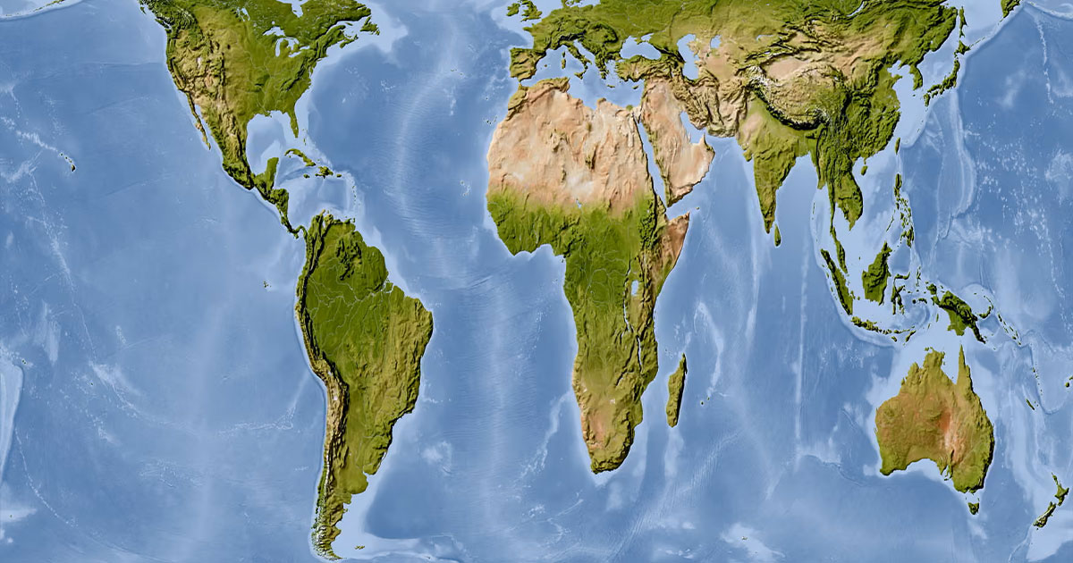
The General Assembly notes that the Mercator projection, which is widely used around the world, distorts the representation of the areas of continental masses located far from the equator, which leads to a relative reduction in the size of Africa and other regions.
DropLand equality… towards more accurate representation
In contrast, the General Assembly declares that “equal land projection” provides a more accurate representation of the sizes of continental land masses, and considers it an appropriate option for improving the accuracy of the cartographic representation of the world. It also stresses the importance of enhancing cartographic representations that are characterized by greater accuracy and scientific integrity.
The General Assembly encourages Member States, international organizations and other relevant entities to adopt, disseminate and use “equal land projection” and isoarea cartographic projection methods, where accurate representation of continental sizes is important. This trend is also linked to the tenth goal: reducing inequalities, from the perspective of promoting a more accurate representation of different regions of the world and making geographical knowledge available in a more balanced way, in a way that supports cultural development in general.

What is Mercator projection?
Mercator projection is a method of drawing a world map invented by the Flemish cartographer Gerardus Mercator in 1569, with the aim of helping sailors determine directions and plot their routes.
However, this projection exaggerates the sizes of the regions near the poles compared to their actual area, so some continents and regions appear larger than their actual size.
Support and opposition
Togo led negotiations on the draft resolution on behalf of the African Group, with support from the African Union, based on a vision that links the accuracy of geographical representation to broader issues related to knowledge, awareness and cultural development.
In this context, Togolese Foreign Minister, Robert Ducey, stressed that the effort does not aim to condemn the overthrowMercator, who recognized its usefulness in navigation, or imposed a single cartographic projection, saying: “A just map changes our view of the world but does not change geography.”
Maps are tools for shaping knowledge
This vision gains developmental importance because maps are one of the tools for shaping knowledge, especially in education and media, as the way the world is presented can affect individuals’ perception of the position, size, and geographical characteristics of regions and continents.
Therefore, the development of cartographic representation is linked to enhancing geographical and cultural awareness, and providing more accurate and balanced knowledge, which supports the path of cultural development and is linked to the goals of quality education and making knowledge available more equitably.
On the other hand, the United States opposed the adoption of the resolution and voted against it, considering that the initiative goes beyond the technical aspect of the maps and carriesBroader political and ideological dimensions.
The American delegate said: “This decision mocks the work and goals of this institution,” adding that what is presented as an attempt to modernize cartographic proportions falls within “a larger, more radical ideological project,” and pointing to the references in the resolution to reparations and cognitive justice.
How to produce and present knowledge
This discrepancy reveals another aspect of the debate, related to how knowledge is produced and presented, and who determines the tools used to interpret the world and teach its geography.
In this context, the importance of developing educational and cognitive tools emerges, allowing for a more accurate representation of geographical and cultural diversity, while preserving the different scientific and practical uses of each cartographic projection.
From a scientific standpoint,Equal-area maps limit the distortion caused by the Mercator projection in representing the sizes of areas near the poles, while they do not increase the true area of the African continent. This allows a more accurate comparison between the actual areas of the continents, which enhances the quality of geographical knowledge and supports building a more accurate awareness of the world.
In conclusion, the issue of representing the world on maps reveals a dimension that goes beyond the limits of geographical accuracy to the way in which knowledge is constructed and transmitted from one generation to another. The map that the student learns from, the media uses, and appears on digital platforms contributes directly to shaping his perception of the world and the status of its regions and continents. Hence, reviewing cartographic distortions is related to improving the tools with which we read this geography, in a way that enhances cultural awareness, supports more accurate and balanced knowledge, and gives cultural development a broader space to relate to education and production.Knowledge.
Therefore, the The Earth Guards Foundation confirms that interest in the accuracy of maps falls within a broader concept of development based on the development of man and the tools of his knowledge in addition to the development of resources and institutions. Correcting geographical representation, when based on scientific knowledge and respecting the versatility of cartographic projections, can contribute to building a more aware awareness of geographical and cultural diversity, and enhance the value of quality education as an entry point to producing more equitable knowledge.


