
Egypt is redrawing the map of mineral wealth with a comprehensive aerial survey to enhance investment

Egypt redraws the map of mineral wealth with a comprehensive aerial surveyto enhance investment
Mineral wealth represents one of the important axes for achieving Sustainable Development Goals (SDGs), as countries seek to invest their natural resources in a way that supports economic growth, and at the same time preserves the rights of future generations.
With the escalation of economic and environmental challenges, sustainable development has become a major framework for achieving a balance between exploiting resources, promoting social justice and protecting the environment, especially since the world is now experiencing increasing competition and an accelerating demand for strategic minerals and raw materials associated with modern industries.
In this context, Egypt seeks to reposition themining sectorsector within its development priorities, through projects aimed at transforming untapped natural resources into economic value that supports growth and expands the production base. Among these projects is the aerial survey of mining wealth, and this is what we will discuss in the following lines. So keep reading.
Aerial Mining Survey Project
The comprehensive aerial geophysical survey project for mineral resources comes as one of the most prominent movements that reflect the trend towards comprehensive development, especially with its connection to the Sustainable Development Goals (SDGs) related to economic growth, industry, innovation and rational management of natural resources.
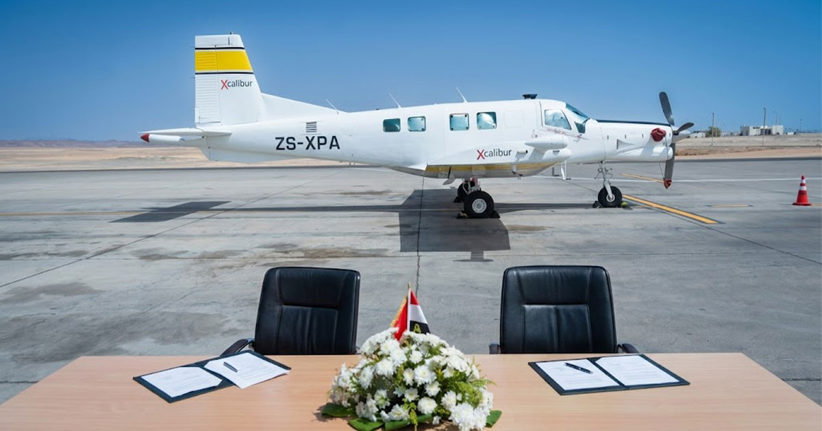
Hence Engineer Karim Badawi, “Minister of Petroleum and Mineral Resources,” witnessed the initial signing of the contract for the implementation of the comprehensive aerial geophysical survey project for mineral resources at the level of the Republic. In preparation for the start of survey work using a specialized aircraft equipped with the latest technology.
It is a project that represents the first comprehensive aerial survey of the mining sector in Egypt in more than four decades! This gives it strategic importance in light of the market’s need for modern, high-accuracy geological data. It is expected that the results of the survey will contribute to providing detailed maps of mining ores, which will help present new areas for investment to local and international companies.
Therefore, the government is betting that the project will contribute to reducing research and exploration costs, and reducing the risks associated with mining investment, which may enhance Egypt’s ability to attract foreign capital to the sector, especially with the increasing global demand for minerals associated with clean energy industries and advanced technology.

A new map of mineral resources in Egypt
According to the Mineral Resources and Mining Industries Authority, the survey project will cover six main geographical areas, including:
- North and south of the Eastern Sahara
- North and south of Western Sahara
- Sinai
- Bahariya Oasis
- Abu Tartur area in New Valley Governorate
The project also relies on employing the latest technologies for collecting and analyzing geophysical data, in cooperation with specialized national institutions, which reflects a trend towards maximizing the use of local capabilities, and linking international expertise with the national technical infrastructure.
Mining reforms in Egypt
The launch of the project is also linked to the package of legislative and regulatory reforms that the mining sector has witnessed during the recent period, most notably the transformation of the Mineral Resources and Mining Industries Authority into an independent economic entity, which gave the Authority greater flexibility in implementing strategic projects and expanding international partnerships.
This step reveals a gradual shift in the way mining resources are managed within Egypt, from a traditional model based on extracting raw materials on a limited basis, to a more comprehensive economic model based on building advanced databases, raising the efficiency of exploration, and increasing the sector’s competitiveness regionally and internationally.
In an analytical view, the importance of the project seems beyond the implementation of technical survey work; It reflects a growing realization that possession of accurate information has become an essential part of the economic power of countries. Because the more accurate data a country possesses about its natural resources, the greater its ability to plan industrial planning, attract investments, and reduce economic waste associated with poor information.
From this standpoint,Earth Defenders Foundation views the comprehensive aerial survey project as a step within a broader path to rebuilding the Egyptian mining sector on more modern and sustainable foundations, in a way that enhances the role of the sector and its contribution to the national economy, which supports – in one way or another – efforts to diversify sources of income and achieve long-term development. Long.


